Demon Peak / Ridge Trail via Watersprite Lake Trail Facts
Demon Peak is part of a ridge extension known as Demon Ridge [Demon Peak is on the west end away from Dreadnought Mountain] which wraps around Watersprite Lake near Squamish, BC.. As you veer off the old logging road, the ridge opens up to some beautiful views of Mamquam Mountain and Garibaldi Mountain.
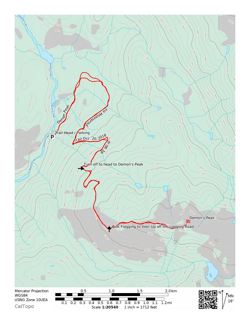
Quick Summary – 20 km of rugged forestry road; 4×4 high clearance recommended otherwise you’re going 5-10 km for an hour. Start on Watersprite Lake Trail. Veer off left at KM= 4.7 before the Prow Lookout. Old logging road with many overgrown bushes. Pink Flagging to veer up. Climbing through trees and an unmarked trail up to the peak. Experienced hikers only. Ability to get lost = high.
Distance: around 16 km
Time: Allow 6-8 hours Roundtrip + Factor in 45-1hr each way on the Forestry Road (HK Hiking Time – 6 hrs 29 min R/T; Total Time with drive on Forestry Services Road – ~8 hrs 20 min)
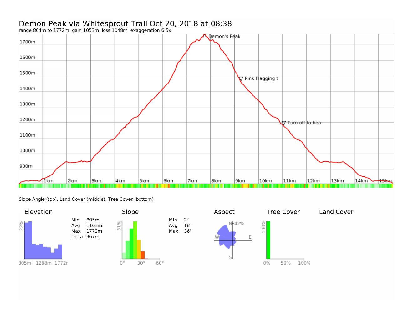
Elevation Gain: ~1094m + (3,589 ft) – although depends where you park
Max Elevation: 1760m (5,774ft)
When to do the Hike: June-October (depends on how fall turns out) and how much snow
Overnight: Yes; but can be done in a single day; multi-day add-on’s can occur
Map of the Route & GPS data: Yes!! Click here for Route or via Viewranger
Dog Friendly: Yes, but only if experienced with climbing mountains.
HK Plan: Day Hike
Note: This hike starts off well marked, but becomes unmarked and un-flagged. It’s dog friendly, however bushwhacking and a sense of navigating the path is required.
Fun Fact – Demon’s Peak is only 28m shorter than Brunswick Mountain.
Part 1: The Bumpity Bump Bump Road In
The trail head is at the tail end of an unnamed road – which is a fun 20 kilometers down Mamquam Forestry Services Road. [Click here to input into Google Maps & make your life easier] Basically, drive just past the chief and if you are driving towards Whistler, you’ll see on you right Mamquam River Forest Service Road. Directions are here.
Allow for 40-60 minutes depending on your vehicle. 4WD + high clearance is recommended. For context, we left downtown Vancouver at 6:30AM, and got to the trail head at 8:38AM.

One of the bridges you crossover on the FSR. 
The FSR road – well pass KM 17 on the logging road. 
Entry Gate at Watersprite Trailhead. 
Trail Kiosk Map Board.
Part 2: Watersprite Lake to Start
8:40AM – The first part of the trail begins at Watersprite Lake Trailhead. From the bright yellow gate, you walk to the right up the hill towards the map board.
- The trail starts off rocky but is pretty level with not much elevation gain.
- You walk along some boardwalks that help you surpass the swampy areas. Some off springs from Demon Creek. At this time the year, the ground was pretty much frozen and it was 0 degrees C out when we started.
- You continue along the marked old forest road path into the forest, eventually passing over Skullhead creek. You are in and out of the forest environment, doing a little bit of up and down. This area has a beautiful transformation during the day.
- About 20ish minutes later, there is a 3-way junction. Follow the sign to go right, as this will lead you on the correct way. Going left – will take you on a bush whacking adventure up towards Mamquam Mountain.
- After going right, the trail is fairly flat and easy, which allows a descent pace to be set. Then you veer left and up the long rocky switchback you go for ~600m.
- Then you veer right at KM= 3.77, and the views of the surrounding area begin to open up. And it is quite a beauty.
- Continuing on, the path levels off a bit and you pass the KM = 4 / 1074 m marker. And shortly beyond, you reach the junction for the Demon Ridge Trail at KM = 4.7.
- We opted to take a break at 9:58 just beyond the junction at the lookout area called “The Prow Lookout”. There’s some pretty epic views, which are even more enjoyable while taking a breather and enjoying a snack.

The view at the start of the trail. 
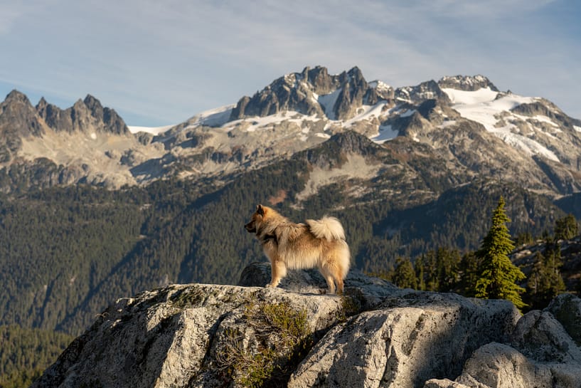
Jack running happily up and down this trail. 
The initial boardwalks to pass the swampy ground (in our case frozen). 
First 3-way junction. Go right. 
Forested trail as you begin the first climb. 
First sneak peak view at Garibaldi as you climb the first continuous switchback. 
KM – 4.00 marker at an Elevation of 1074 m. 
Continuing along the trail towards the “Prow” lookout. 
Following the team. 
Gorgeous views at the “Prow” Lookout. 
Gorgeous views at the “Prow” Lookout – looking towards Garibaldi.
Gorgeous views at the “Prow” Lookout – looking towards Mamquam.
3-Way Junction to Veer off to Demon Peak/ Demon Ridge 
Jack enjoying his break and his chew stick of the first leg.
Part 3: Veer off onto an Old Forestry Road
After enjoying the scenic views at Prow Lookout, we went back to the junction to veer off left to go up and even older logging road. The trail veers up a switchback and another switch back as you begin to gain elevation. The switchbacks some what block your views, but eventually the view opens up once you pass a group of boulders. The view to the right is beautiful. However, you need to keep a look out as you traverse forward as you eventually veer off this old logging road and head up into the forest.

Garibaldi off in the distance. 
The peaks poking out. 
Jack in stick heaven. 
Another look over to Garibaldi. 
Flagging along the forest road. 
The sun coming through. 
The fun bushy section to climb through. 
A break through the final climb. View over to Mamquam. 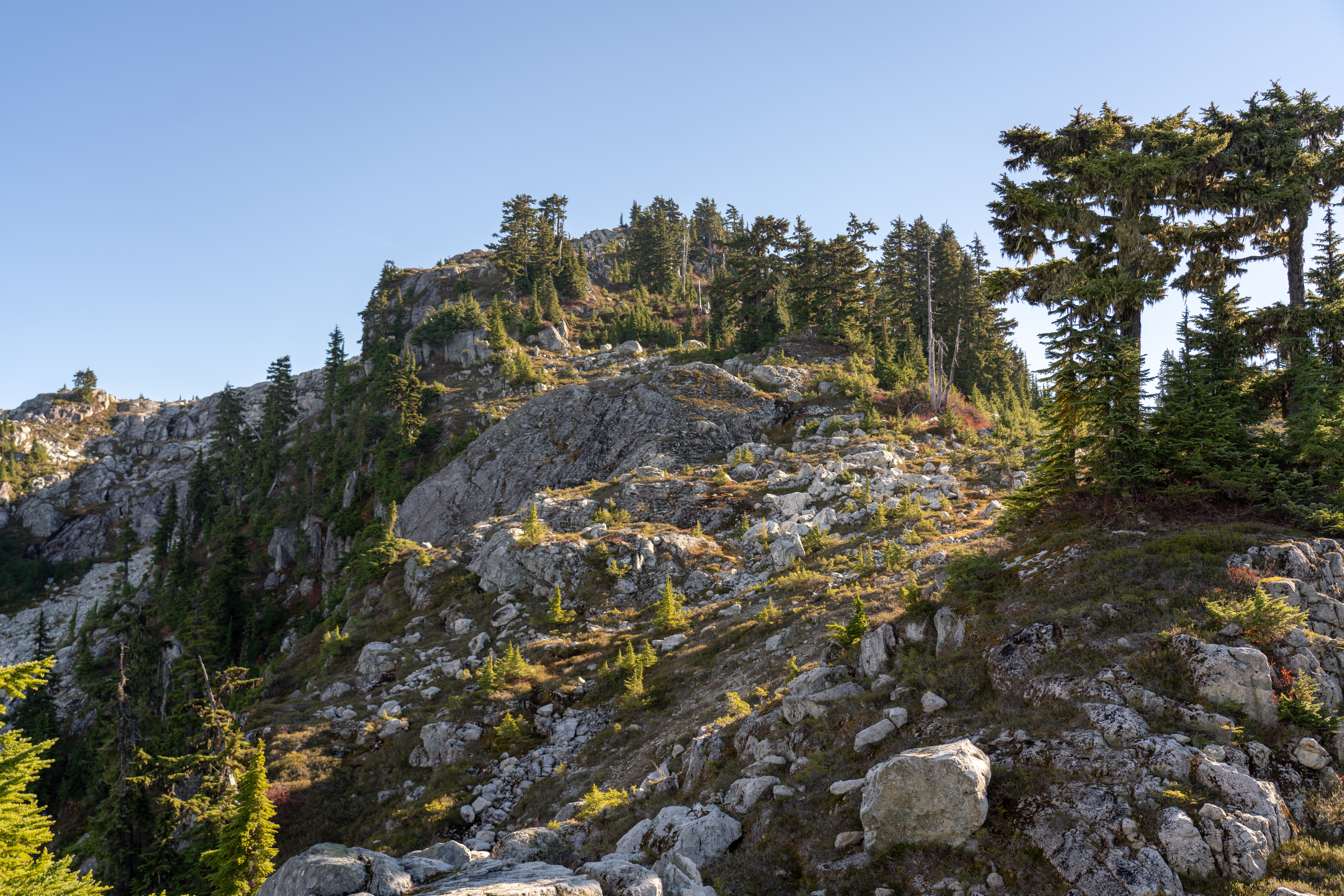
The view up towards Demon Peak. Such a tease. 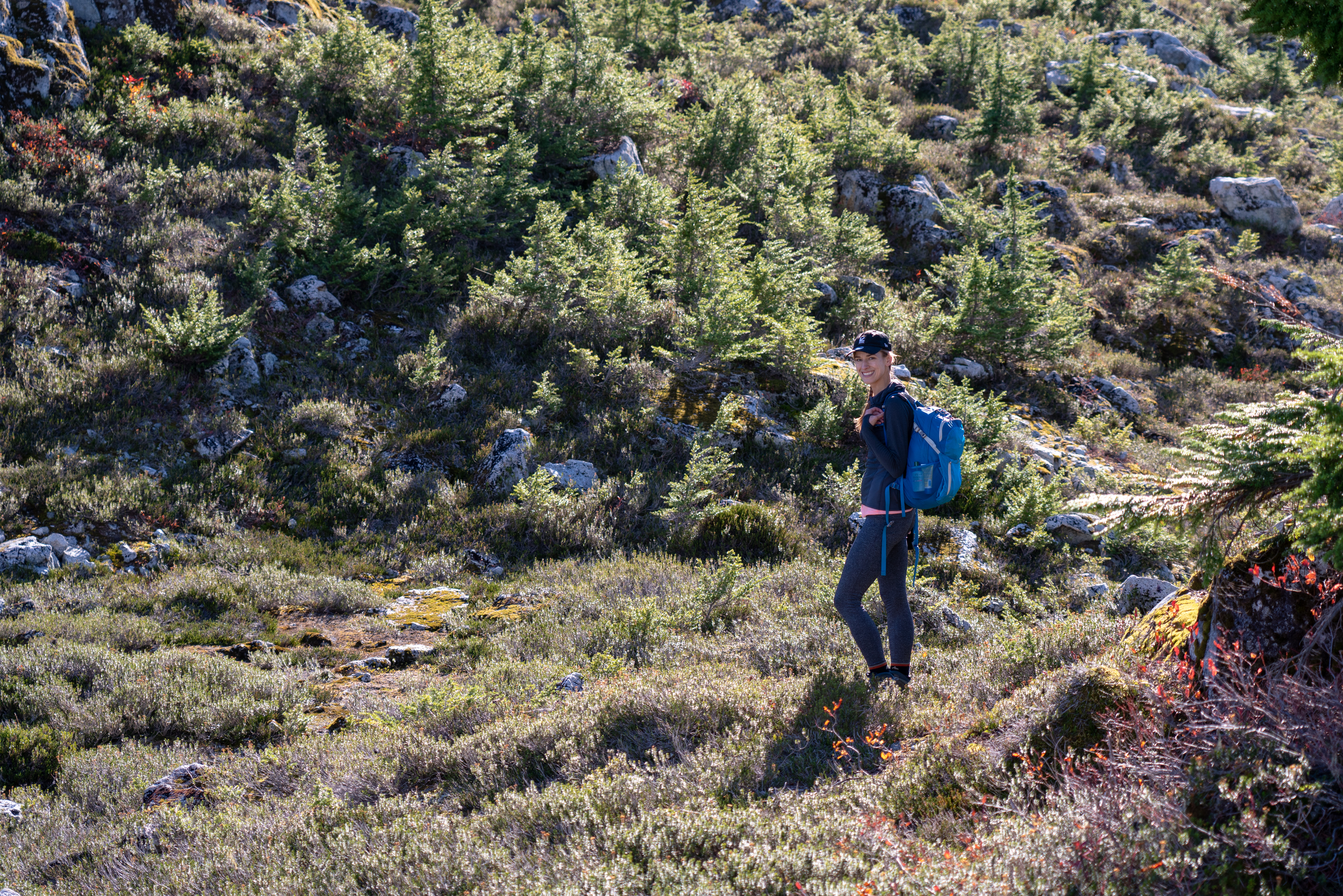
H taking a breather. 
The climb up towards the peak where you are making your own route. 
A look back at the bushy path.
Part 4: Bushes, Trees and Demon Peak
At ~ KM = 6.33 there is flagging and a mini cairn which you turn left to get off the logging road (note it can be easy to miss, so keep an eye out for it). Following the turn off, there’s some flagging tape to help guide you through the forest path First you pass through a narrow trail, then enter an area filled with lost of forest growth and toppled over trees. The flagging can be hard to spot, but follow this as you continue up the mountain. We second guessed ourselves multiple times on the direct path to follow, however the direction to climb does remain clear. Up.
The flagging ends at around KM = 7.25 / elevation ~ 1709 m. So it’s a make your own path beyond this point. You can continue on wards toward Demon Peak. The trail contains a lot of bush and fallen down trees, so be careful as you continue along with you hike. When you think you are at the peak, it’s a tease. There’s another hump to climb over. Shortly after the mind tricks, you reach the peak (there’s a rock cairn as the giveaway). The view is epic. You get a different perspective on Garibaldi, a close up of Mamaquam and a neat sighting of the lions way back in behind. Photos show the beauty better than a written description – see following galley.
Key Tips/ What to Bring:
- Layers layers and more layers. We started out the hike at 8:38. It was around 0 degC. At the peak, it was warm-ish in the sun In the shade it got quite cool too. So layers. I highly recommend investing in some decent, breathable base layers.
- At the time of year we did this climb, there’s a water sources along Watersprite Lake trail. However, when you veer off for Demon Peak the sources are next to none. So bring extra water, or a proper filter for the small ponds up near the peak.
- Need a warm jacket – best option for when it’s cold, crisp and dry out.

Jack exploring. 
Happy Pup. 
Jack taking in the view. 
Team pose. Mamquam in behind. 
K and Jack. Garibaldi in behind. 
Continuing on towards Demon Peak. 
Flagging as we near Demon Peak. 
Mamquam Mountain. 
Nearly there. 
Jack’s Lake. 
The rock cairn at the top of Demon Peak. 
The sweeping views of Garibaldi Provincial Park. 
Different perspective of Garibaldi Mountain. 
Looking towards the ranges that frame around Watersprite Lake. 
Standing on the Peak looking over at Crawford W2. 
Mamaquam Mountain. 
Garibaldi. 
Jack taking in the summit views. 
Happy dog. 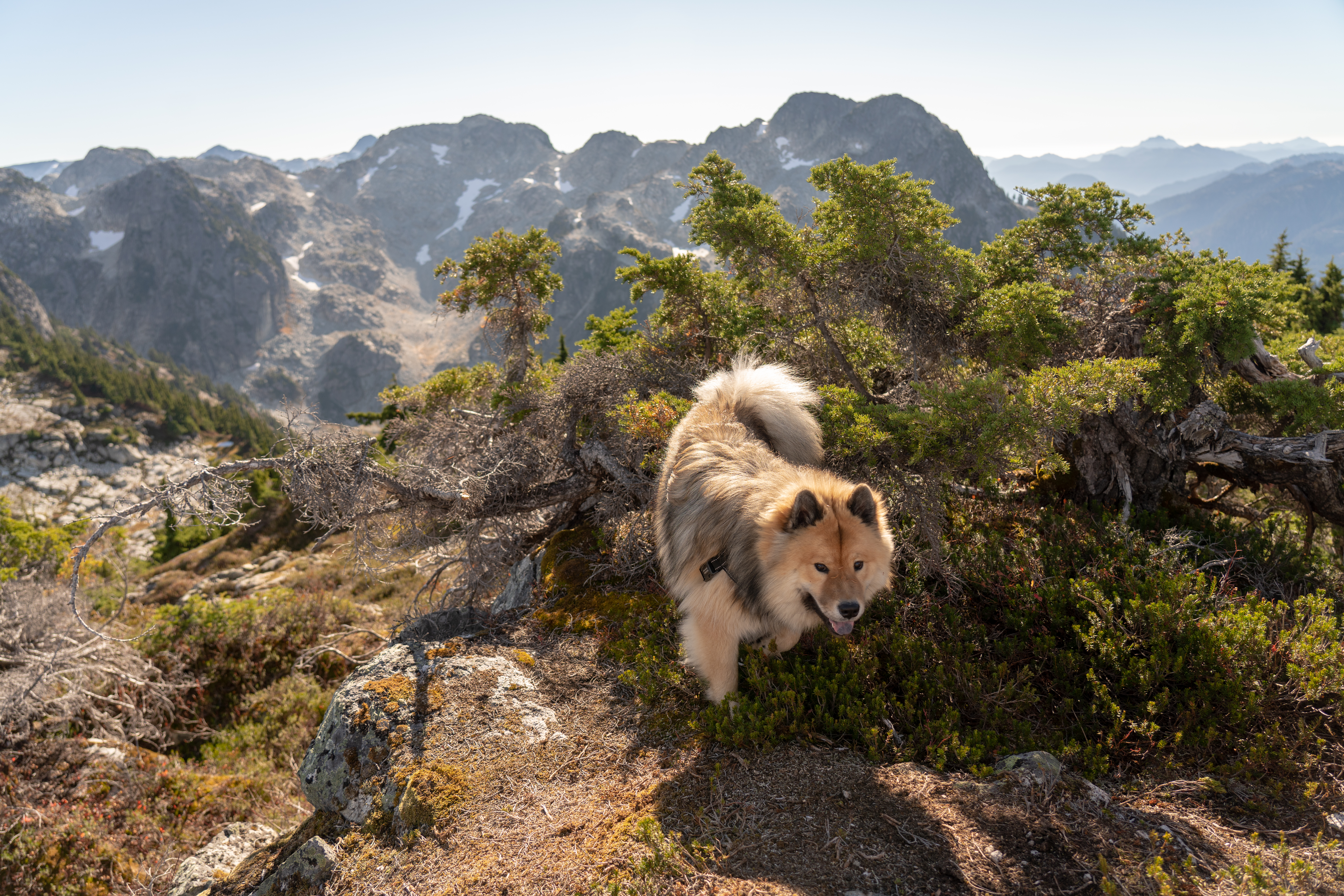

Watersprite Lake down below. 

Mamquam Mountain 


Bald Eagles flying above. 
Running around the peak. 
Looking back towards Squamish. 
Slowly making our way down along the trail. 
Final leg heading back to the car. 
Happy team.
Reply
You must be logged in to post a comment.