West Coast Trail Hike Guide: Fact’s, Tips, Itineraries and Planning
The following is our trip report for the epic and beautiful hike along the West Coast Trail WCT in Pacific Rim National Park Reserve, Vancouver Island, BC. There are many great resources on Parks Canada for what to plan and to pack. We’ve linked in the referenced items where necessary. This post is a highlight of our journey, our game plan and itinerary, the lessons learned, and what we would attempt to try if we had a time machine.
The West Coast Trail is an ever-changing adventure filled with non-stop beauty, scenery and history. Originally an access route to help rescue ship wreck survivors along the coast and filled with many First Nations Communities along its course, the access path has been turned into one of the most sought-after hiking destinations around the world. For us, it’s a bucket list item close to home that we had to experience.
- Distance: ~75 km (~46 miles) Start-to-Finish
- Time: 6-9 days (hiker preference)
- Elevation Gain: Varies Daily (see Day recaps for specific’s)
- When to do the Hike: May-September (best months are July & August)
- HK Dates: July 18 to July 26, 2018
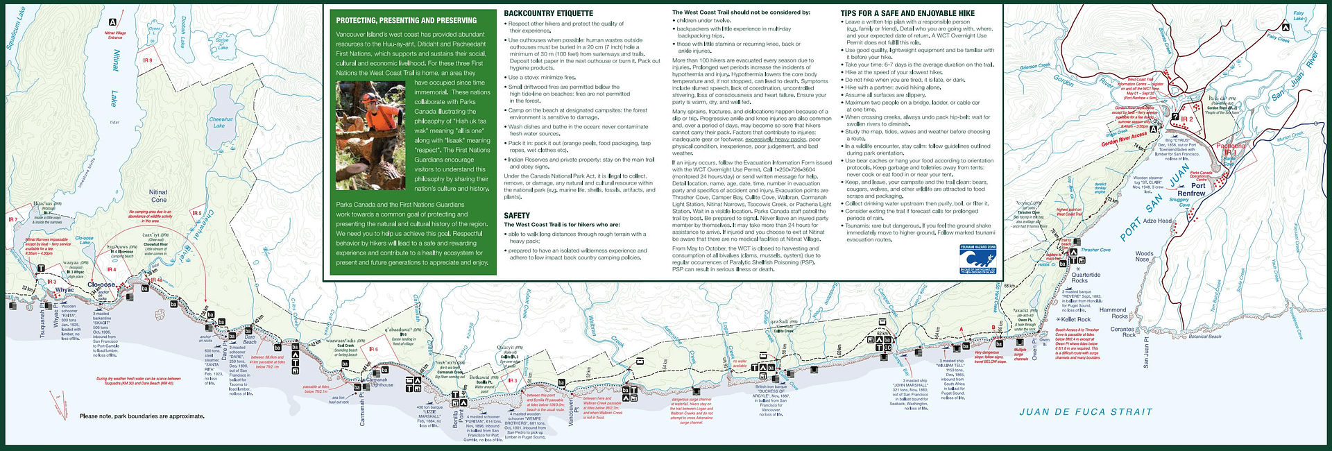
- West coast trial Map of the Route & GPS data: Yes!! Click here for Route
THE DETAILS:
- HK Plan/ West Coast Trail Prep List
- What to Pack
- Day 0 Getting There/ Orientation
- Day 1 Gordon River to Thrasher Cove
- Day 2 Thrasher Cover to Camper Bay
- Day 3 Camper Bay to Walbran Creek
- Day 4 Walbran Creek to Carmanah Creek
- Day 5 Carmanah Creek to Dare Beach
- Day 6 Dare Beach to Tsusiat Falls
- Day 7 Tsusiat Falls to Michigan Creek
- Day 8 Michigan Creek to Pachena Bayjoy the Accomplishment/ Recovery/ Key Lessons Learned
Team Plan: West Coast Trail Planning – Team Fancy Pants Plan
- Tide Tables: Port Renfrew
- Tide Tables: Bamfield
- Need help reading a tide table: A quick run down


Reply
You must be logged in to post a comment.