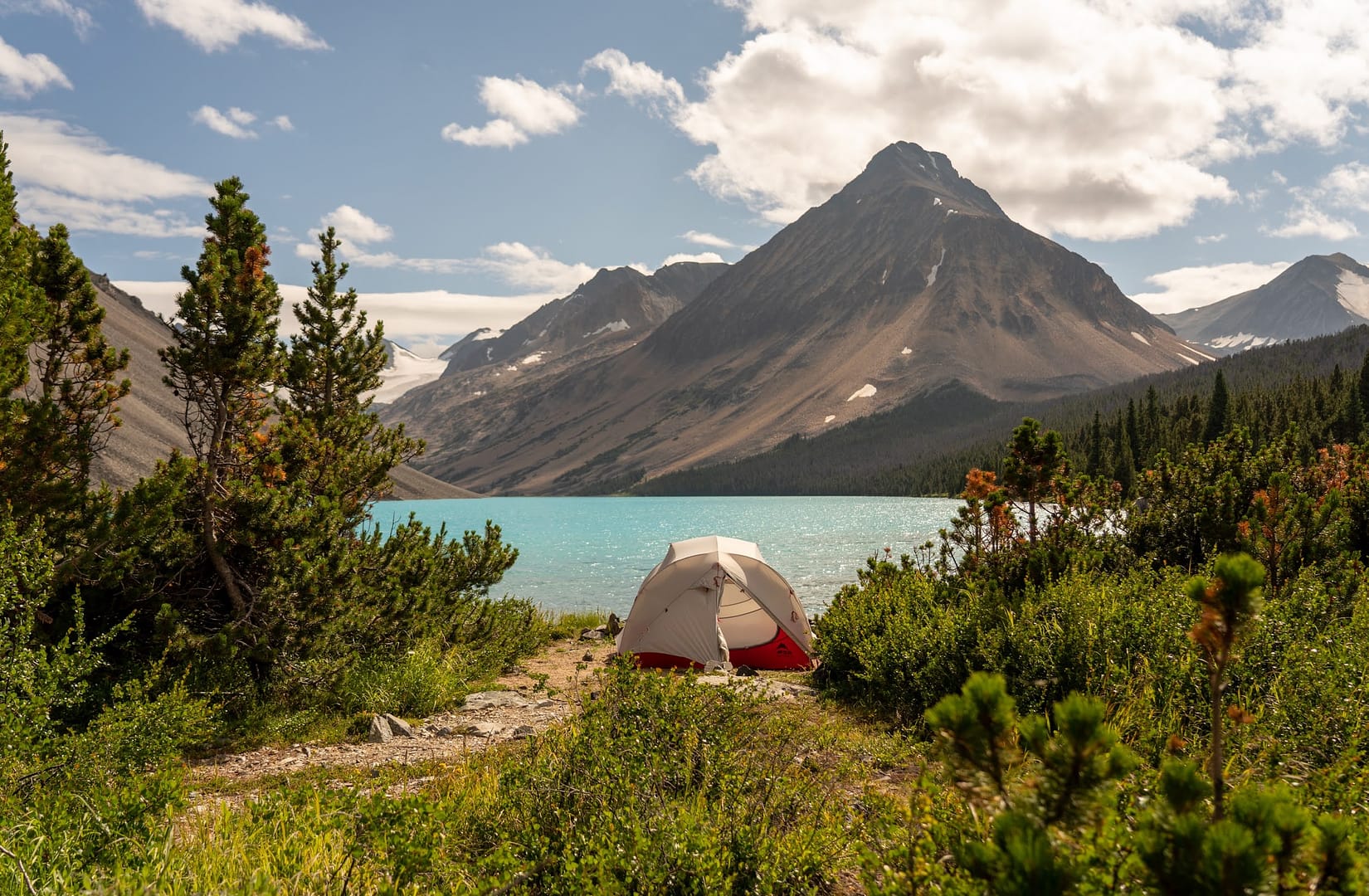
This is a quick post of our epic backcountry loop hike through the South Chilcotin Mountains in July, 2021. Though this post is long overdue, we hope it can still be useful for others. The South Chilcotin mountains are absolutely stunning, it’s some of the most incredible terrain we’ve ever seen.
We had planned on visiting this area for a few seasons and extremely please we finally did. In short, we covered 144.86KM with 5,500m of ascent, over 6 Days on foot with our doggo Jack. We saw a wide variety of terrain, gorgeous lakes and even some Grizzly bears. Anyways, here’s a quick write up that we hope you enjoy. If you have any specific questions, reach out to us on Instagram @HKTreks.
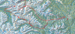
The Route
We had originally intended to spend 8 days in the South Chilcotin backcountry but left a ton of room for adjustments based on things like weather, muscle aches and just overall contentness with any given spot (if we love the area, we stay longer and vice-versa). All that said, at multiple times we also found ourselves just having a great time walking, so we kept on which in-turn made for long days!
One specific callout was our journey on Day 4 up Big Creek and Grant Creek, over Iron Pass, down to the Taseko Rivers and then around Warner Pass to Warner Lake Camp. This was initially a toss up for us as we couldn’t find any great beta on terrain past Iron Pass, in the end we’re glad we did it. We’ll cover that day in more detail further down this post.

Day 0: Vancouver to Tyaughton creek camp site
We packed up Snoopy and hit the road nice and early. We Decided to head up straight to Pemberton from Vancouver, then up to Gold Bridge via the lovely and coveted Hurley FSR (forest service road). The condition of the Hurley greatly depends on the time of year you decided to drive it. It is our opinion that you should have a higher clearance vehicle SUV, maybe even an all wheel drive or 4×4, to comfortably cross it. That said, we have see MANY passenger cars crossing, albeit some with flat tires. Check here for latest road conditions.
Once in Gold Bridge, the drive to Tyaughton creek camp site is fairly straight forward. You travel approx 12km on Carpenter Lake rd then turn onto Tyaughton Lake Rd and follow that for approx. 26km. Google maps is your friend, so please reference that for accurate directions.
The Tyaughton creek campsite is fairly small and situated right by the river. We decided to setup camp here, relax, pack our bags and then hit the trail early the next morning.
Day 1: Lower Tyaughton creek trail to WD Trail camp
The drive from the Tyaughton creek camp site to the Lower Tyaughton creek trail head is maybe a 10 minute drive. There is sufficient room to park your car, though when we got there, there wasn’t a single one in sight. The same rang true for when we’d return a few days later.

The hike begins on the Lower Tyaughton creek trail and immediately gains elevation, the first kilometre is especially steep and really an excellent warm up. Overall, we covered 15.4km with a gain of 772m to get to WD Trail camp.

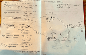
As you can see from the profile, there is a fair bit of up and down valley type hiking to get to WD Camp. The good news is that once you get past the first kilometre the views really start to open up. Since the trail hikes up and down valleys, there were several occasions to fill up on water, though this is very likely to not be the case in the latter months of summer. The trail was mostly clear but with the exception of a few deadfall areas, which weren’t too bad. Anyways, here are some photos.


The WD trail camp site sits along the Tyaughton Creek, and there are two main camping areas that we saw. The first just up from the creek in meadows and the second right beside the river. We opted to setup camp at the latter primarily so as to have a water source near by, it was hot!


There’s nothing quite like sleeping by a rushing river, best sleep ever. The next morning we’d be on our way continuing along the Mid Tyaughton Creek Trail. Since we were planning a loop, we’d come across WD trail camp on our way back in just a few days. It was reassuring to see the log bridge in good shape.
Day 2: Mid Tyaughton creek trail to Lorna Lake camp
Day 2 was awesome! We had a rough plan to continue along the Mid Tyaughton creek trail, connect to the Lorna Pass trail and then head into Lorna Lake to find a camp spot and oh boy, did we ever find a nice one at that!

We were really looking forward to getting up through Lorna Pass and into more of the mountainous landscape. Hiking along the mid Tyaughton creek trail wasn’t especially scenic, though plenty of river crossing and a consistent elevation gain kept us entertained. Day 2 had us travelling just over 19km with an elevation gain of 890m, so a fairly good day with our full packs.


The hike up into Lorna Pass is gorgeous. The views quickly open up and you really start to see the beautiful Chilcotin ranges both behind you and in front. The initial climb into the pass is steep but well worth it. This was the first time we ran into any other humans, mostly of the mountain bike type.

The hike over Lorna Pass and into Lorna Lake is pretty straight forward. The descent is well defined with only a few spots that have particularly loose rock, easy does it on the way down. Once into the flat lands, it’s a very short walk into Lorna Lake camps. There are two camping areas at Lorna Lake, one in the forest near the water plane docks (Lorna Lake Wilderness Campground) and the other at the end of lake near the sandy beaches. We opted to stay at the latter.


A few minutes after setting up camp we spotted three Grizzly bears traversing on the ridge along Lorna Lake. We made ours presence clearly known to the bears and they proceeded to turn up the ridge and continue their traverse up into Big Creek. We’ll never forget the sunset that night, what a sight as the falling rays lit up the glacial lake and towering ranges. We spent the evening eating, recollecting the sight of those bears and planning our adventure for Day 3.
Day 3: Day hike – Lorna Lake Camp to Dorrie Ridge and back
I woke up fairly early the next morning and spent about an hour preparing coffee and embracing the sunset views with Jack. The water on Lorna Lake was absolutely still and mirrored the mountain ranges magically.

We decided that we wanted to spend the day exploring the Lorna Lake area with a day hike up into Dorrie Ridge. We were making good progress, our backs needed a break, we were craving some views of this area and well, the camp was just pretty magical.
We rolled the dice and decided to try and cross the forested area into Sluice Creek, then planned to traverse along the creek and up into Dorrie Ridge and the backside of Warner Ridge. Day 3 had us travel 12.4km with 627m of elevation gain. There is no visible trail when crossing from Lorna Lake into Sluice Creek, though the forest isn’t too thick and as long as you have some form of navigation, it is fairly easy walking.


Once into Sluice Creek, the views became spectacular and only enhanced as we gained elevation into Dorrie Ridge. There are no trails or markers here, so if you decide to head into this area, please be backcountry prepared and comfortable with navigation.


After taking some time to enjoy snacks, the epic view and the traverse we’d be taking on tomorrow, we headed back to camp. The journey back was largely uneventful, though the views as we ascended back into the valley were absolutely stunning.
Once back at camp we mostly mirrored Jack.

Day 4: Lorna Lake to Warner Lake via Iron and Warner Passes
This was quite the day. We had tried to do some research on this Day 4 route but unfortunately any available information was either partially complete or many years old. We decided to use our backcountry experience to take a chance and go for it. Our original plan was to hike from Lorna Lake to the junction of the Task river, then setup camp there. When we got to that junction, we still had lots of sun left and the bugs were bad, so we decided to trek on over Warner Pass and to Warner Lake Camp.
All in all we ended up hiking about 38km with an elevation gain of about 1440m, what a day!


We woke up at sunrise, quickly packed, drank coffee and started our trek. The morning walk was absolutely bliss. Sun was rising over Big creek and the weather was sweet.

We traversed along the Big Creek trail until we reached Elbow Pass, which quickly connects to the Grant Creek Trail. This whole portion of our morning was absolutely stunning. The light, the reflections of the mountains, the dew rising off the marsh, it was all just so overwhelmingly beautiful.


The trek along Grant Creek was very peaceful, we saw a variety of wildlife including deer and a wolf. As you get closer to the elevation gain of Iron pass, the trail is practically non-existent and bushwhacking is required. It’s not too bad but be prepared for thick, tall and branchy bush.


The ascend into Iron Pass was steep and windy but the gorgeous wildflowers absolutely make it well worth it. We found ourselves constantly looking back down the valley, the views were incredible.


Iron Pass was so windy that we could hardly hear each other yelling! I can’t say much about the views other than to let the photos do the talking. The whole part of this day from Iron Pass, then down to the Task River felt unreal. The terrain was extremely vast and felt like an imaginary land you’d see in a Lord of the Rings film. There was a strong prevalence of Grizzly Bear prints as we ascended over Iron Pass, so we were intentional about being a little more alert.

As you Descend down the Grant Creek trail there is again no trail in sight, so everything is dependant on GPS and pre-planned Caltopo navigation. The descend into the valley is fairly straightforward as the trail continues to wind down. Eventually you meet an abandoned mining route that is fairly obvious to spot, you then follow this all the way down to the Taskeko River.


We quickly made it to the Taskeko river where we had some lunch, refilled on water and enjoyed a caffeine boost. What’s neat writing this post now is that a year later, in the Summer of 2022, we’d end up exploring the Taskeko Lakes area but that’s for another post!

From the junction of the Task river we would ascend into Warner Pass via, you guessed it, the Warner Pass Trail. This hike was just a long slog with a good amount of elevation gain. The heat at this point in the day was pretty intense but luckily a large portion of the route is forested. Once you get into the alpine the real climb up to the Pass begins. The views here again are just stunning, we found ourselves taking many breaks to just soak in the views of the valleys and peaks.


After slogging up the Warner Pass Trail for some time, we finally made it up into the vast alpine that nears Warner Pass itself. The views here were again spectacular though at this point we were getting determined to get to Warner Lake, setup camp and eat some dinners (yes plural).


Once at Warner Pass, the descent to Warner Lake was quick and steep with tons of loose scree. Parts of the descent are extremely steep and with tired legs, we made sure to take our time navigating the ridges down into the valley and eventually to our camp site at Warner Lake.


Once at Warner Lake, we quickly setup camp, ate a well deserved dinner and quickly hit the hay reminiscing on the adventure we had just completed.

Day 05: Warner Lake to Trigger Lake with Day Hike to Deer Pass
After hiking almost 40km on Day 04, we wanted to rest a little on day 05 and get up into the mountains with only a daypack. We woke up in a frozen tent, quickly made coffee, packed up and bolted down to setup camp at Trigger Lake. Legs were sure feeling spicy this morning. Day 05 would have us travel 19km with just over 800m of elevation gain.


We packed really light for the hike up to Deer Pass, which turned out to be a great decision given how steep the ascend was and how hot it was in the exposed terrain. We met quite a few people around Trigger Lake and on the trail up to Deer Pass, contrast that to not seeing anyone for the last two days.


The views at the top of Deer Pass were quite nice but the terrain was very exposed, hot and extremely windy. We got a glimpse of the trail leading to Mount Sheba, though we made a decision to save that for another trip. There is a water tarn near Deer Pass (see photo above) which some people opt to sleep at. Personally I can’t see that being an enjoyable experience. The whole area is really exposed, windy and the water in the tarn doesn’t look too appetizing.


Once back at Trigger Lake camp, we spent the rest of the day enjoying the sun, chatting with new friends, finally having a good bath and well, relaxing. Our original plan for Day 06 was to hike to Spruce Lake and spend the night there, then head back to Snoopy on Day 07. We iterated on the fly and decided it was time for a cold drink, so we’d wake up before sunrise and head back on Day 06.
Day 06: Trigger Lake Camp to Lower Tyaughton creek trail (Starting point)
We woke up in the dark, quietly packed up, drank coffee and hit the trail. We love early starts, the cool air makes for brisk travel and we wanted to cover as much ground before sunrise as possible, today was going to be an absolute scorcher.
Day 06 had us covering almost 33km with an elevation gain of 1,100m and an elevation loss of 1350m, so it was a big day. One important detail for future hikers, once past Spruce lake, we had intended to take the Spruce Lake trail and connect to the Mid Tyaughton Creek trail. Unfortunately the Spruce Lake trail is non-existent, so we had to get back onto the WD trail and connect from where we had spent our first night. This added some distance that we didn’t really plan for.

The hike to Spruce Lake was pretty straightforward and quick. We took the Gun creek trail from Trigger lake, connected to the Lower Grasslands trail and then the Upper Grasslands trail to the Spruce lake trail. Small note that the Upper Grasslands trail wasn’t in great shape, there was hardly ever a trail so we relied almost exclusively on Caltopo and GPS.


Once we connected to the WD Trail and made it back to the Rope bridge we slept at on day 01, things were fairly familiar and best of all, the loop was officially, a loop! The hike from the junction at the Tyaughton Creek was a long and hot slog. We had a heat wave during this time of the year and we really felt it on this day. We took lots of breaks, drank as much water as we possibly could and made an effort to stay/rest in shade where possible.


I still remember ascending that last 5-8km and just wanting that bag off my back and some coveted snacks I knew were waiting for us back in the truck. We eventually made it though and I think our fondest memory is Jack running enthusiastically towards Snoopy, and jumping up expressively to let him inside.
Thanks for reading and we hope some of this was helpful or at least enjoyable.
If you’d like to follow us along, you can find us on Instagram, or check back here, we’ve got many more posts coming.
Till next time, HK and Jack.
Reply
You must be logged in to post a comment.