Mount Decoeli Fact’s
Mount Decoeli is a climb that results in clear unobstructed views of Kluane National Park and the most sought to see Mount Logan. After explaining this hike to many friends, the best summary to describe this climb is a long steady climb of river rocks along the river, where you eventually reach green hilltops that look like their from the Shire. After the hills, you are faced with the vertical climb of fractured rock on the mountain side up to the summit. Think Frodo climbing to the volcano in Mordor from LOTR.
Mount Decoeli was one of our main goals on our Alaska and Yukon road trip, so we were especially excited to summit this peak.
Distance: 18km (11.2 miles) Roundtrip
Time: 7-11 hours (summit climb takes 4hrs roundtrip)
Elevation Gain: ~1340m (4,400 ft)
Max Elevation: 2330m (7462ft)
When to do the Hike: June-September
Overnight: Yes; but can be done in a single day
Map of the Route & GPS data: Yes!! Click here for Route
HK Plan: Day Hike
Note: This hike is part of our Alaska & Yukon Road trip collection of hikes we’ll be writing about, so stay tuned!


Part 1 River Rocks
The trailhead for Mount Decoeli is a pull out on the left side of the road when you drive in from Haines Junction. It’s roughly 20km north of Haines Junction. Count the markers. Decoeli itself is the last mountain north in the group of mountains that straddle the Alaska Highway. From the lot, walk a bit south until you see a rock cairn that marks the start of the trail.
Tip – you cannot see the summit of Decoeli from the trailhead, it’s hidden in behind and becomes exposed as you traverse your way up.

Follow the first stretch of the trail for ~1km through the trees until you meet Summit Creek. You essentially walk beside this creek for about 5km as you gradually gain elevation. Depending on the time of year and the conditions on the hike, you can choose when you want to cross the river. Be warned, this section of the trail is full on bushwhacking. When you think you in the clear, you are not. You follow the river and make the route the best suits you; some people will try to stick to the left side of the creek the entire way up or walk across the alpine ridge south of the river bed to avoid it completely until the glacier. With our route, we managed to cross the river only once on our ascent to the glacier. There were multiple hops across smaller offspring’s going up but we accepted the bushwhacking where it was required. You continue the gradual climb along the river up until you reach the glacier.


Part 2 Rolling Hills of the Shire >> Scree!
Once at the “top” of the river, you reach the glacier. There is a quick steep climb and then you meet the rolling hills of Decoeli. The hillside bumps with green grass, gophers and many streams merging through a bumpy landscape, which oddly reminds me of a direct scene from the Shire. However, watch you footing. Gopher holes exist throughout.
At this point, you can make camp for the night if you arrive late and want to enjoy the summit climb the next morning. You are situated in a beautiful valley, surrounded by mountains on 3 sides. Mount Martha Black and Mount Archibald in multiple directions, and then Decoeli to the other. When we traversed across the greenery, we were welcomed to the site of sheep across the valley.
Looking up at Decoeli it appears, so small and easy. Don’t be fooled. Decoeli can give off a false sense of hope. The mountain emits “I don’t look so high or so steep; it’s quick to summit me”. Well, that’s more likely if you take the correct route, to run around the mountain vs taking the route we did.


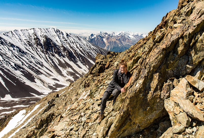
The route the GPX data file was telling us to go, was veer to the north side of the glacier, go around the rocky slope and traverse up mountain side. The route we took is known as the climb “straight to the top” from the toe of the rock glacier in the meadows. This route up the east and south facing slopes are filled with fractured rock, with sounds of runoff water running below, and is steep as f***.
Part 3 Scree to Summit
The vertical climb up the fractured rock was both a mental and physical workout. Taking three steps forward, and slipping back one with each push forward. My love for vertical climbs was elevated by the sound of running water well below the rocks we were relying upon. The climb is not technical if you follow the “actual trail”, however doing the short cut up made for an adventurous work out.
TIP: The last ~200 meters to the summit is the steepest with large amounts of loose rock. Be careful when you traverse up with your footing and what rocks you grab; the rocks break off very easily due to the continual exposure to freeze-thaw cycle. I myself got stuck for a moment. #goodtimes
NOTE: it took us 4 hours from the rolling hilltops to the summit and down.
Once through the vertical stretches of the summit climb, which we took in multiple chunks. We made if to the summit. And that view, was an incredible one. K had wanted to see Mount Logan on this trip. Well mother nature was on our side, as we got a clear view to the massive 100km wide landmass of Mt. Logan. On this clear day, we were rewarded with views of some of the largest ice field landmasses such as Mount Vancouver, Mount Logan, Mount Kennedy, Mount Weisshorn and many more. The scenery at the summit are incredible.


After taking in the beauty and not looking down, we take in one last view and begin the descent down. Now when you are heading down fractured rock, poles are key. As you traverse down the mountain, you go in a swooping motion similar to skiing; or as K calls it “rock skiing”. It was a steep and slippery descent down. Arriving back at the rolling hills, we sit and enjoy a snack and some water while looking back up at the summit we just climbed. It was a satisfying feeling.


After staring at the wildlife, we packed up and made are way down by the river side. As we descended, it was a magical feeling taking in the environment around us. The sounds of nature and the run off of the mountains take over you.
Note – water levels from runoff rise towards the end of the day. so we were forced to cross the creek and unfortunately got more wet than we desired.
Once across the river, we then find the forested path to take us back to the truck. But not without looking back at that scree filled mountain.


Reply
You must be logged in to post a comment.